Biography
I am data scientist at the French national statistical institute, Insee. I study how emerging data or new computational methods help to renew the production of statistical knowledge.
I mostly work with Python
and . I sometimes use C++ to improve performance
or Spark for big data analysis.
I am a huge Git fan.
I also like a lot
the possibilities offered by state-of-the-art data-science tools to
reduce the cost of exploring new datasets or new questions.
Most of my work is available on my Github page or
the Github page
of the Insee’s Lab.
I maintain the utilitR project which is a collective effort involving many people from French administration to propose a high-quality documentation regarding software.
See Projects 👇 and Publications 👇 and Talks 👇 sections for more details.
I currently teach Python for Data Scientists
(Github repository )
at ENSAE Paris Tech,
one of the top French engineering school.
I also teach a course “Reproductibility and good practices in data science projets”
(Github repository )
that brings student to the question of MLops.
I used to teach urban economics at Sciences Po Paris and
macroeconomics for candidates to the Insee exam. See Teaching 👇 section for more details.
- Big data
- Statistics
- Machine Learning
- NLP
- Econometrics
Msc Statistics and Data Science, 2017
ENSAE
Msc Econometrics, 2013-2018
ENS Lyon & Paris School of Economics
Msc Applied Mathematics, 2015-2017
Université Pierre et Marie Curie (Jussieu), Paris VI
Experience
See Projects 👇 and Publications 👇 and Talks 👇 sections for more details.
Website: https://pythonds.linogaliana.fr/
Github page
Reproductibility and good practices in data-science projects
Website: https://ensae-reproductibilite.netlify.app/
Github page
See Teaching 👇 section for more details.
Past courses:
- Urban Economics: Master 1 in geography (2016-2020) ; - Microeconomics: undergraduate, 2016-2017 ; - Mathematics for economists: undergraduate, 2016-2017.
See Teaching 👇 section for more details.
Teaching
List of some courses I gave recently
Python pour la data science
Cours en 2e année d’ENSAE (M1) disponible sur https://pythonds.linogaliana.fr/
Reproductibilité et bonnes pratiques pour les projets de data science
Ce cours donné en dernière année de l’ENSAE et construit avec Romain Avouac est disponible sur le site web https://ensae-reproductibilite.netlify.app/ (dépôt ).
Travail collaboratif avec R et Git
Cours pour découvrir la manière d’utiliser R dans un projet collaboratif avec Git créé à l’Insee avec Mathias André, Romain Lesur, Annie Moineau et Olivier Meslin.
Le contenu du cours est disponible sur le site web https://collaboratif-git-formation-insee.netlify.app/. Le code source est disponible sur le compte Github InseeFrLab
2019: Macroeconomics
Undergraduate macroeconomics course for exam preparation at INSEE
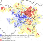
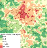
2016-2019: Urban Economics
Urban Economics course at Sciences Po. Program available here
2016-2017: Mathematics for Economics
Undergraduate mathematics course at Sciences Po
2016-2017: Microeconomics
Undergraduate microeconomics course at Sciences Po
Projects
A list of open-source or research projects I participated in


Featured Publications
Recent Publications
Recent & Upcoming Talks

Recent Posts
Some blog posts I wrote about data-science, statistics or informatics